- Home
- Programs
- Metro Planning
- Metropolitan Planning Organization
- Transportation Planning
- Safety for All Modes
- High Fatal and Injury Network
High Fatal and Injury Network
The High Fatal and Injury Network (HFIN) shows all fatal and injury crashes that have taken place in the region over a five-year period, highlighting the most dangerous streets and intersections. MRMPO uses the HFIN to identify recurring patterns in specific locations to help target limited funding to these problem areas. Specifically, this means those corridors and intersections that are above average for the region. Above average pedestrian and bicycle crashes along roadway segments and at major intersections are also included.
A Targeted Geographic Approach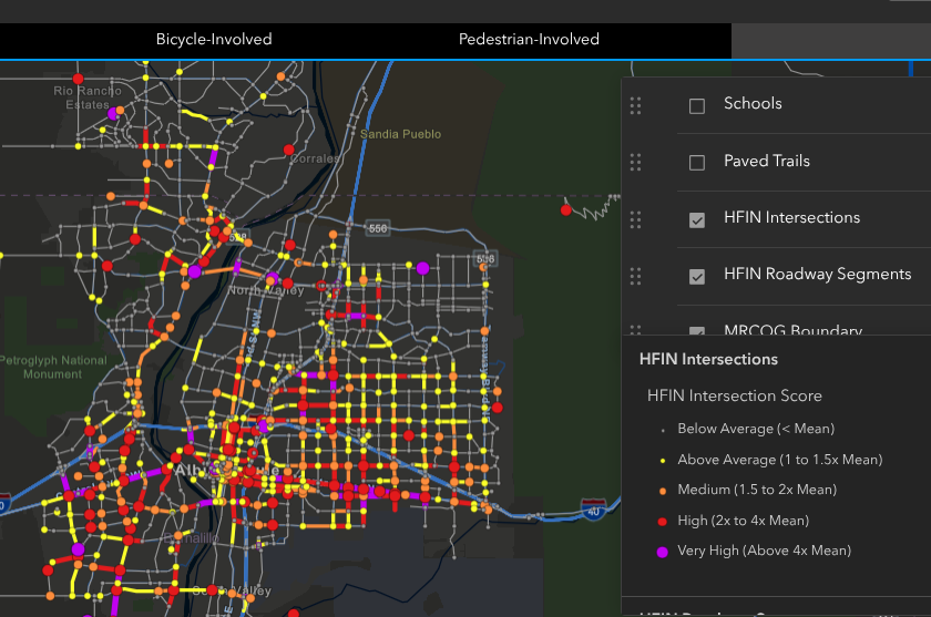
The HFIN is meant to be a guide for decision making by helping identify locations where safety improvements can make the greatest impact. Like any high-level planning document, each location requires further engineering study to determine the main safety concern and appropriate strategies.
The HFIN reveals that 64% of the total fatalities and injuries on our region’s roadways occur on only 7% of the Major Roads (Collectors and Arterials) network.
Because of this, a targeted approach of improving the most dangerous roadways would be a strategic and effective way to enhance safety.
Interactive Map
View the current Interactive Regional HFIN Map (2019-2023)